q

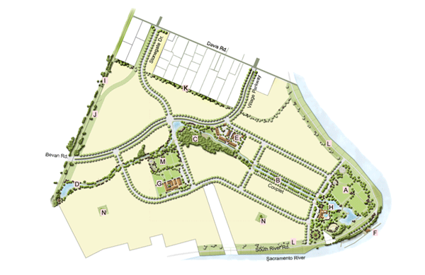
River Park Master Planned Village - An Illustrative Plan

(click on image to see larger view)

A Community Park
B Urban Park
C Oak Preserve Park
D Residential Park
E Neighborhood Commercial Center
F Water-Related Commercial (Marina)
G Elementary School
H Community Center with outdoor aquatic facility
I Yolo “Rails-to-Trails” corridor
J Landscaped Utility easement
K Open Space buffer along existing Rural Residential
L Open Space buffer along levee
M Neighborhood Park
N Pocket Park

The River Park plan supports a balanced mix of land uses: approximately 2,788 residential units, 6 acres of Neighborhood Commercial, 2.6 acres of Water-Related Commercial, a 10-acre Elementary School, a 40-acre Community Park, and approximately 65 acres of community parkway and open space. A detailed land use table is shown below.


River Park Land Uses


Land Use Type
SFP Designation Acreage Dwelling Units
Rural Residential RR 22.9 22
Low Density Residential LR 144.3 728
Medium Density Residential MR 168.1 1446
High Density Residential HR 31.9 592
Neighborhood Commerical NC 6.0  
Water Related Commercial WRC 2.6  
Open Space OS 24.1  
Parkway OS-PARKWAY 29.9  
Recreation Parks RP 52.4  
Roadways ROADWAY 12.2  
Total   494.4 2,788

Note: SFP=Southport Framework Plan