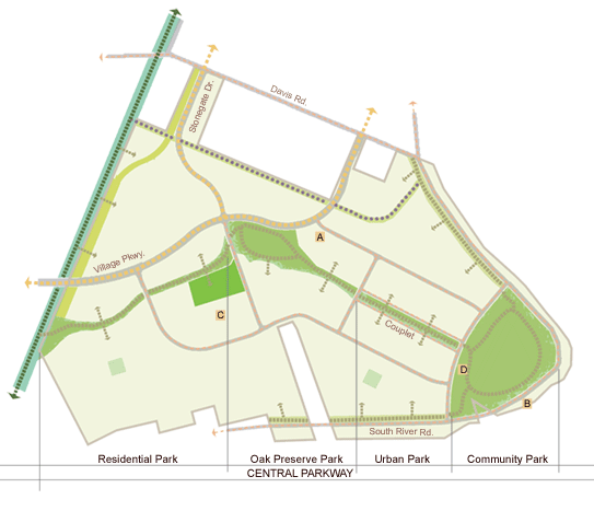
River Park: Parks, Open Space and Trails Diagram
(click on image to see larger view)
| A | Neighborhood Commercial |
| B | Water-Related Commercial |
| C | Elementary School |
| D | Community Center |
| Central Parkway | |
| Neighborhood Parkway | |
| Pocket Park | |
| Yolo "Rails-to-Trails" Corridor | |
| Landscaped Utility Easement (Lower Northwest Interceptor) | |
| Open Space Buffer along Existing Rural Residential | |
| Open Space Buffer along Levee | |
| Bike Lane (Caltrans Class II Bikeway) | |
| Bike Route (Caltrans Class III Bikeway) | |
| Bike/Pedestrian/Equestrian Trail | |
| Bike/Pedestrian Trail | |
| Equestrian Trail |
The Parks and Open Space Framework Plan for the River Park master planned village is a refinement of the original plan for the Southeast Village. The River Park plan provides 76 acres of parks and open spaces proposed in the Southport Framework Plan; furthermore, it protects the site’s existing natural resources, providing additional 30 acres of community open space above that proposed in the Southport Framework Plan.
The River Park plan includes the following parks and open space amenities:
- A 40-acre Community Park in the eastern portion of the Village, including both active and passive recreation uses;
- A 6.6-acre Neighborhood Park site adjacent to the central open space corridor and Elementary School site;
- Two 1-acre Pocket Parks located amid residential uses;
- A 30-acre Central Parkway extending from the Community Park westward to the Yolo “Rails-to-Trails” corridor at the western boundary of River Park, that will preserve the site’s natural resources, such as an existing irrigation canal and oak woodland, and will provide a central bicycle/pedestrian trail system;
- Public open space along the Yolo “Rails-to-Trails” corridor, connecting to the regional equestrian/bicycle/pedestrian trail network;
- Public open space buffer along the Sacramento River levee, featuring bicycle/pedestrian trails that will connect to the regional levee trail system; and
- Public open space buffer along the existing rural properties at the north end of the River Park site, featuring an equestrian trail that will connect the Yolo “Rails-to-Trails” corridor to the regional levee trail system.
